A
Life of Ley Hunting
1975
Theories regarding stone circles
Are Freemasons and Foresters societies the last vestiges of a kind of "twin priesthood"; one looking after the stones and the other the wooden sites?
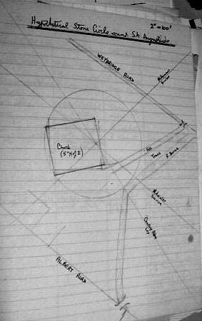
St. Augustine's, Addlestone
as possible stone circle site
 Near River Bourne,
and below Woburn Hill which had ruins of a chapel on it. Good ley centre with
midsummer and midwinter sunrise lines good leys.
Near River Bourne,
and below Woburn Hill which had ruins of a chapel on it. Good ley centre with
midsummer and midwinter sunrise lines good leys.
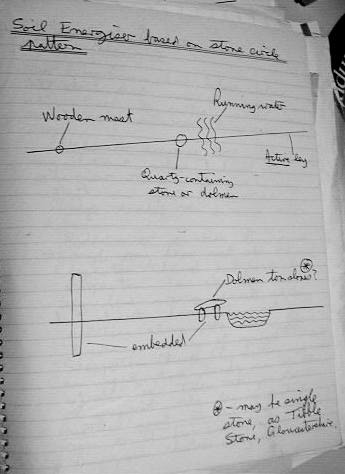
Midwinter sunrise line runs through my allotment where I built an energiser to see if there is any effect on plants. Noticed midges tended to swarm over dolmen.
Midsummer sunrise line runs through my home and also through Shepperton Church and War Close, Shepperton. In War Close on the line was a small sapling bent almost horizontal, not quite pointing along the line. Above it was a swarm of midges (13/7/75). Near Shepperton Church (in Rectory grounds) an apple tree bends in the direction of the ley. These things tend to suggest the ley is active.
Another good St. Augustine's ley which goes to Windsor Castle, priory at Runnymede, Chertsey Abbey etc, passes through bend in river. Standing on the bend, a definite "ley feeling" in the head was felt.
From the position of the rising midsummer sun as viewed from my home (on the St. Augustine's midsummer sunrise line) and from aligning the map at the bend in the river the ley centre is found to be at the east end of the church, probably in the middle of the chancel. This would presumably be also the centre of the stone circle if there was one.
St. Augustine's Leys
Midsummer sunrise line is not a good ley from points observable on the maps.
It joins St. Augustine's to Shepperton Church and passes through an island in
the Thames, and a footpath crossing-point in Upper Halliford. However, it seems
to be an active ley judging from the tree evidence at War Close and Shepperton
Church.
Midwinter sunrise line is much better on the map, as it skirts St. Anne's Hill hillfort, goes through two churches in Chertsey, Addlestonemoor junction, St. Augustine's, over allotment to two cross-roads and centre of Whiteley Village.
Chertsey Abbey Ley is the very good ley which first drew attention to St. Augustine's as a ley centre. It goes through Windsor Castle, a church in Egham, Chertsey Abbey site, St. Augustine's, Caenshill at Weybridge, skirts St. George's Hill, cross-roads south-east of Dorking, runs along road with parish boundary for 1/8 mile, Ewhurst Place at Crawley.
Apparent confirmation
of theory at Pyrford, Surrey.
Pyrford parish church (St. Nicholas) is in a circular churchyard near the top
of a hill, thought to be a prehistoric site. A quarter of a mile away are the
ruins of Newark Priory, low-lying and surrounded by streams. The church is about
1140, the priory about sixty years later - another example of an abbey with
a hilltop chapel.
Near the church is the Pyrford Stone (made of sarsen) now incised with a cross. Apparently it was originally a crossroads mark stone (thought by local historians to be prehistoric) but not in its original position. This position has not been established yet (in relation to leys - stone not marked on map).
Pyrford is especially interesting as it is a hilltop church which is thought to have prehistoric origins, in a circular churchyard. There are Scots pines in the churchard even today, as well as an ancient yew tree. Under a wall-painting of the passion of Christ in the church was an earlier fresco painting which shows mounted horsemen fighting with spears, and a row of men wearing conical hats and carrying staves. These are apparently not found in wall paintings elsewhere.
Ley joining Pyrford
Church and Newark Priory.
Cross-roads Foxhills (Nr. St. Peter's Hospital), Pyrford Church, Newark Priory,
unmarked centre Hatchlands (nr. East Clandon), cross-roads south of Gomshall,
skirts Holmbury Hill (hill-fort), junction of Stane Street and minor road. 6,
possibly 7 verifiable points. 2 other leys through Pyrford Church.
Energy felt more at church than priory, though a little at latter where altar was, though this is a distance from the surviving parts of the abbey.
Wisley Church similar to Pyrford Church, similar date. Straight path aligning to St. Mary's Byfleet, visible on skyline. Lone Scots pine by gate. Stone - ancient? in porch - irregular. Similar energy to Pyrford. Ley joining Wisley to Pyrford 52o N - a midsummer sunrise line? Line goes through St. George's Hill.
St. Mary's Byfleet, old, no history in church to get details but very much stronger energy than either Wisley or Pyrford. Ley joining Wisley and Byfleet churches also goes through Newark Priory.
Leys in Wales
Parc-y-Meirch
double trees
St. Johns in the parish of Llanfair Talhaiarn double tree avenue and very strong
energy felt.
Llannefydd (Mynydd y Gaer) quartz-encrusted limestone.
Rhuddlan Castle - Tothill looked ancient though called Norman (had appearance
of spiral as at Glastonbury).
Denbigh Castle - trees around.
Denbigh friary - sandstone, glinting quartz. Aligned 70o
Moel Arthur - slate
Stone circle near Nannerch, nr. stream. Only 4 main stones left, but many stone
fragments scattered around. One stone seemingly embedded in centre, but not
sure if this is original. One of the stones had a leonine face as observed at
Stanton Drew, having expression of intense sadness. Circle of trees now seemed
to replace stones, mainly oak but one elm, unaffected by Dutch elm disease.
Circle area completely covered in nettles. Large stone a distance from circle,
on path with avenue of copper beeches, later found on a ley to Henllan church.
Llannefydd Church - seeming energy. 80o.
Valle Crucis Abbey. Energy in church to east end mainly . Sandstone, surrounded
by hills.
Henllan church. Aligned due east. Detached tower to south-east, walls of tower
aligned with east end of church. Energy quite powerful. Stone walls with fossils.
Leypower detector (Sept
1975)
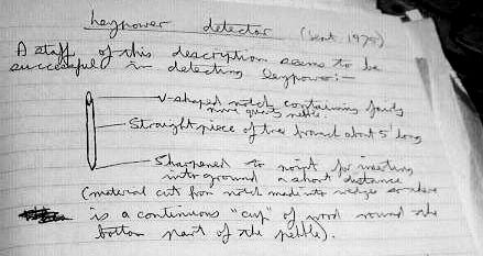 A staff of this
description seems to be successful in detecting leypower:
A staff of this
description seems to be successful in detecting leypower:
V-shaped notch containing fairly pure quartz pebble.
Straight piece of tree branch about 5' long.
Sharpened to point for inserting into ground a short distance (material cut
from notch made into wedges so there is a continuous "cup" of wood round the
bottom part of the pebble.
When this staff is inserted into the ground at an active place and the forefinger placed on the crystal with thumb and other fingers on the staff, a tingling is felt, varying in intensity with different locations, eventually "discharging" or disappearing, not reappearing till some time later.
Staff would not operate when millstone grit (containing quartz) was substituted for the pebble.
Staff is reminiscent of the dodman's staff and caduceus, and also fits in well with the wood and stone theory.
Stopped working - see March 76 device.
The presence of oak trees "replacing" the stones at the Nannerch stone circle made me think that perhaps oak and pine are opposite polarities, and when stone circles are destroyed and not replaced by churches etc. to continue their work, the regenerative power in leys causes oaks to grow to replace them. The pine always seems to be the tree of high places, and its significance in leys is well known (Tony Wedd and Alfred Watkins). Could calcium carbonate be the mineral with the same polarity as pine? We have Stony Littleton of limestone, and chalk hill figures in chalk country (Long Man and Cerne Giant both had abbeys beneath them).
Evidences:
1 Philip Heselton's headache machine incorporated a quartz crystal which could
be replaced by an acorn.
2 Oak and pine have opposite "sex rates" in T.C.`Lethbridge's table - oak has
a female rate and pine a male. There is also outward sex symbolism in the tall
pines and rounded oaks.
If the basic "hill-river-circle" machine had a similar effect to the Deland Installation in California, the whole country planned this way would have had an effect on the weather, making it considerably warmer.
The Great Pyramid had a limestone facing (now no longer there), a granite core (i.e., the various chambers, and a main body of sandstone.
In The Old Straight Track there are several references to tapping markstones with rods (in various ceremonials, e.g., some civic ceremonies, and the London Stone being tapped with a sword). Perhaps there is a clue to levitating stones here. There is a possible connection with piezoelectric-type effects with pressure on quartz at ley points.
The stone circle-river theory seems to be backed up by T.G. Hieronymus's experiments with photosynthesis. Plants, in total darkness, grew green and healthy in aluminium lined boxes connected (earthed) to a water pipe by copper wires, and to by separate wires to a copper plate exposed to sunlight. Earth-water-fire elements seem present here too - were the boxes wood? The presence of running water does not seem to have occurred to the inventor as being important.
Kent Leys
Kit's Coty House (a dolmen - limestone) on a hillside north of Maidstone has
an interesting ley in the direction it is facing, passing through a centre in
a bend of the Medway now occupied by a "works" (stone circle site?), then West
Malling Abbey and a ruined chapel, track junctions and "The Devil's Den" south
of Edenbridge.
Midsummer sunrise ley from Kit's Coty passes through Mereworth parish church, as well as several minor points (cross-tracks etc.) This church was built in the eighteenth century in Roman basilica style, but has very strong energy.
The Hog's Back Ley (Hog's Back to Stonehenge) passes south of this, near Mereworth Castle, probably through the site of the original Mereworth church. The present one seems an example of subconscious siting. The ley also goes through Kent Hatch, a pine clump mentioned by Tony Wedd.
Return
to List of Years
Return to Homepage